
BackgroundER To the North Hill Coulee and Confederation Creek
The following is a condensed document written by “The Friends of Confederation Creek” concerning the past and future of the valley. Includes links to City of Calgary documents.
The Friends of Confederation Creek (FOCC) are very encouraged by our dealings with City Administration and their preliminary Confederation Park Stormwater Drainage Study report's findings. http://www.calgary.ca/PDA/pd/Pages/Current-studies-and-ongoing-activities/Highland-Park.aspx
This study looks at the natural and man-made watershed of The North Hill Coulee. This coulee (in orange) was formed by the retreat of Ice Age glaciers and there has been water flowing in it, around the southern foot of Nose Hill since that time. This image comes from P. Meyboom's seminal “Groundwater Resources of the City of Calgary and Vicinity,” AER Bulletin 8, 1961. (Bulletin 8, 1961 https://ags.aer.ca/publications/BUL_008.html)

This coulee is part of the largest water catchment in Calgary. The catchment is 2700 hectares, encompassing communities from present day Shaganappi Trail NW to Edmonton Trail NE on the south side of Nose Hill; from Brentwood and Varsity communities to Highland Park and Thorncliffe Greenview communities.
You can explore the changes in the area from 1924 to the present through this interactive slider map prepared in the new “Healthy Rivers” ‘Story Map’ the City of Calgary, Water Resources department has developed: https://maps.calgary.ca/healthyrivers/ (Zoom in around the south side of Nose Hill.)
The Story Map has been created as an educational tool to create awareness about The City’s Riparian Action Program (RAP) and the initiatives being pursued under this program. The RAP can be downloaded from this weblink - http://www.calgary.ca/UEP/Water/Pages/Watersheds-and-rivers/Riverbanks-and-Floodplains-in-Calgary.aspx
By FOCC' s measurements 1,576,800 cubic meters of permanent water flow through this Coulee per year without the addition of storm water. Confederation Creek's base flow is >.050 cubic meters per second.

Base flow of confederation creek
Legend
N25 >.050 M3/Sec
Confederation Creek/Trafford .050 M3/Sec
McKnight Creek .0006 M3/Sec
D86 QPC .007 M3/Sec
D33 Confederation Park North .040 M3/Sec
CP4 Confederation Park North .0017 M3/Sec
Total Yearly Minimum Flow 1,586,800 Cubic Meters
A generation ago, a group of citizens formed to create Confederation Park, which includes Canmore Park (now West Confederation Park), Confederation Park Golf Course, and the Park. Prior to this there were a few people living within the future park’s confines. This painting of the little farm by local resident Betty Ogle, who lived on neighbouring Constable Road, depicts her neighbourhood at the time when St. Francis High School (1962) was built. Many locals remember the horses that were boarded here. This area was to become the Confederation Golf Course.

The Confederation Park citizen’s group recognised the amenity the Creek offered and kept it in daylight in the Confederation Golf Course and Park. They are remembered in present-day City of Calgary signage.

Welcome to Confederation Park
The stream and lagoon at Confederation park were part of a stormwater management system that was innovative at the time.
Before the park was developed in 1966-67, natural springs led to a small creek running down the ravine. When snow melted or during a heavy rain, the valley flooded. The Parks Department channeled water into a larger stream and lagoons. The lagoon system made it easier to develop facilities such as the golf course and baseball diamonds. It was the first time they had used natural features to collect and treat stormwater from the surrounding neighbourhoods.
The Park is where most Calgarians know the Creek and may be why Confederation Park is Calgary's most popular park and was declared a Municipal Historic Resource.
http://www.calgary.ca/CSPS/Parks/Pages/Construction/Confederation-Park-Improvements.aspx
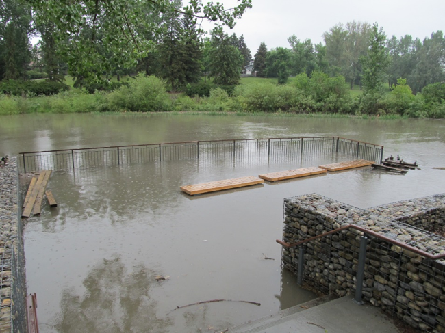
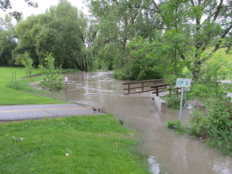
Because of the large amount of water from its catchment, Confederation Park floods regularly following rainfall. These photographs are from June 23, 2018, after a short rainfall. (https://www.timeanddate.com/weather/canada/calgary/historic?month=6&year=2018)
The Creek goes into its vault at 30 Ave NW, but regularly escapes it in Queen’s Park Cemetery, with several manholes acknowledged to be problematic by the City of Calgary. This photograph is the pedestrian entrance to the Cemetery off 4 St. NW, following a rainfall in 2012.

Further downstream, The Highland Park Valley is the bottleneck of the Creek in Confederation Park that meets at least three other creeks in the valley. This valley, formerly known as the Highland Park Golf Course, has been a contentious site between private owners and City Administration since it was acquired in the late 1950s by Mr. Adderson, who also developed Highland Park. The use and zoning of the valley has come before previous City Councils numerous times, including when the City expropriated the land on May 10, 1971 with Bylaw 8196. (You can read more about this time period here The Highland Liability.) This photo shows how the creek used to appear in the former golf course, prior to being vaulted.

More recently, the future of the valley came before Council in 2001, and 2008. You might ask sitting Councillors Farrell and Colley-Urquhart for their memories of those occasions.
One groundwater spring forms the wetlands in the Valley east of 4 St at 42 Ave NW. This wetland has been re-establishing itself since the golf course ceased operations. It is presently artificially drained into Confederation Creek.
The McKnight Boulevard Creek and the Eggerts Park (also called Trafford) Creek are also vaulted and add significant amounts to the vaulted Confederation Creek in the Highland Valley. This composite photo shows these creeks as they were documented in 1951, with labels.

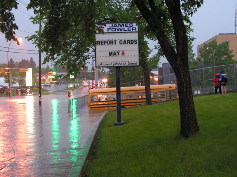
FOCC supports the findings by AE Engineering, a third-party expert's report to City Administration, and City Administration recommendations to City Council that recognise the public safety risks and increased future volatility and future flooding in the North Hill Coulee due to climate change. In 2011 a man died on 4 St. during a “flash flood” https://calgary.ctvnews.ca/storm-contributes-to-calgary-man-s-death-1.680287
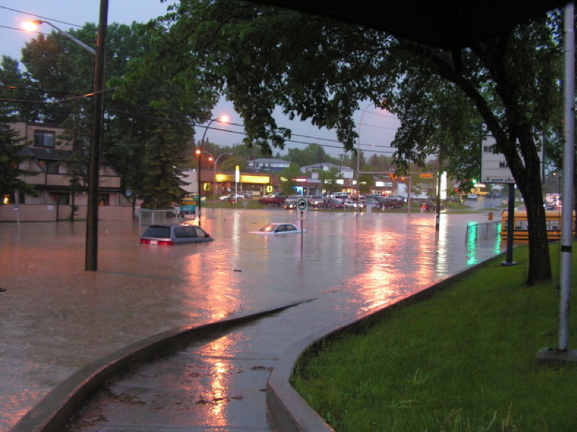
The following photographs of 4th St and 40th Ave NW are from the 2012 flooding referred to previously.

This photograph is of outfall N25, where Confederation Creek meets its trunk, Nose Creek, at the corner of Edmonton Trail and the 32 Ave NE Connector. It was taken after the same June 23, 2018 rainfall shown in previous photographs of Confederation Park flooding.
Friends of Confederation Creek understand that Council must keep some information private, like negotiating the purchase of the necessary land for stormwater storage in the Highland Valley as recommended by City Administration. But the final Confederation Park Drainage study should be released to the public as promised, to also inform about other outstanding issues in the Coulee.
We ask that you give the information provided by the FOCC here your due consideration.
Thank you.
More information and pictures can be found at Friends of Confederation Creek facebook page.